Introduction
How the idea of this book developed
Background information
Description of location
Some general notes about the book
 
 
How the idea of this book developed
When I signed my two year contract with the German Development Service to work for the Namibian Directorate of Forestry at the Kanovlei Forest Research Station in June 1995, I was very excited about the future and the opportunity of staying two years within a !kung community. But of course I had my fears as well. As I was the first development worker with a horticultural background within the Directorate of Forestry, I wondered what my contribution to Namibian Forestry could be.

The need to work on non-timber forest products was identified and I was asked to concentrate on this - to identify important plants and record their uses. In addition, the propagation of indigenous food plants should be explored with the overall aim to ensure food security by cultivating adapted food plants near to homesteads. With the population increase in West Bushmanland and laws governing hunting, the !kung community there is no longer able to just live from its traditional hunting and gathering activities.

In January 1996, I started to accompany the women of the station on their gathering tours into the bush. Initially, it was a strange feeling: I, equipped with rucksack, sufficient water, food, camera, plant press and note book, and the women only with a little collecting bag. Later, when I had more confidence and more experience, camera, plant press and note book were enough. At first, I was only shown food plants, but later on the women also explained to me the use of medicinal plants and plants of traditional use. Once, during a workshop on food conservation, I sat on one of the three Camelthorn branches (Acacia erioloba) which fed the fire for cooking jam, and from the kind of discussion in Vasekele, I could feel that something was wrong. I carefully checked myself, but so far I could not find anything unusual. Finally however, the headman came to me and asked me not to sit on the branches of the fire; this would cause an early death of my husband and they would not like him to die. Of course I immediately stood up; I also would not like him to die. But when they saw my frightened face, they laughed and said that white people often are immune against the dangers of their tradition.

The more the people knew about my interest in their use of plants, the more information I received. But I also observed that it was mainly the older people who had an astonishing knowledge of the plants. When I asked younger ones for the name or use of a special plant, they often did not know. I also wondered how all the information I had gathered could be made available for the people who were to continue with this project after my two years were over. It was then that the idea grew of conserving the still available knowledge for the future in a book. The Directorate of Forestry agreed, the German Development Service provided the funds and the idea became reality.
I then decided to try and get in contact with traditional healers, this turned out to be no problem at all and two female and one male traditional healer from Kanovlei and Luhebo openly shared their knowledge with me. Their contribution has greatly enriched the book, especially in terms of medicinal usage of plants.
  Top top
 
 
Background information
The study area of this publication is the western part of Bushmanland, north east of the Otjozondjupa region of Namibia. The area is commonly referred to as West Bushmanland, and this name is used throughout this publication.

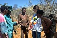
West Bushmanland has about 2000 inhabitants, mainly !kung. They belong to three different tribes - the Ju\oasi, Punguvlei and Vasekele. The ancestors of the Ju\oasi lived in the eastern part of Bushmanland as hunter-gatherers and even today, this region is mainly populated by them. The ancestors of the Punguvlei came from the Rundu area and those of the Vasekele from South Angola. Both groups lived as hunter-gatherers, but also practised to some extent shifting cultivation due to earlier contacts with Bantu tribes and the Portuguese. Both Punguvlei and Vasekele people came to Bushmanland during the time of the South African occupation, when they were employed by the South African Army and stationed in West Bushmanland. At that time, West Bushmanland was mostly unpopulated as there was no surface water. The South African Army drilled boreholes and so enabled people to settle permanently in West Bushmanland.
Today, most of the villages in Bushmanland have developed from former army bases and depend on government diesel for generators for their water supply. The !kung people are no longer nomadic, but live permanently in villages. Hunting and in particular gathering still play important roles in their livelihood, especially for those who do not have a job or any other income. This is the case for most of the !kung, as the unemployment rate amongst them is an estimated 95%! While the Ju\oasi still live from hunting and gathering only, the Punguvlei and Vasekele have continued with their tradition of cultivating fields. They grow mahango, sorghum, maize and vegetables like beans, pumpkin, melons and different kinds of plants for harvesting leaves. The work on the fields is mainly done by hand, although the Ministry of Lands and Resettlement sometimes provides a free ploughing-by-tractor service and some !kung started to plough with cattle. However, other than chickens, they usually do not have any livestock. Most of the livestock in Bushmanland belongs to Herero, Damara, Kavango or white people who have settled in Bushmanland at the time of independence or after.

The Kanovlei Forestry Research Station, which was my home from January 1996 to January 1998, is about 170 km north east of Grootfontein and 120km west of Tsumkwe. It was established in 1989 on top of a dune 4.5km from the main Grootfontein to Tsumkwe road (C 44) in the middle of the bush.
Today, the station employs six labourers, one driver and one ranger. It is inhabited by about 60 people, mainly Vasekele. As the contact with the people at the station was naturally the easiest, a lot of information was received from them. This has meant that information from Vasekele sources is more comprehensive than from Punguvlei or Ju\oasi.

After about one year I realised that it is necessary to know more about the Vasekele language in order to be able to write down the correct Vasekele names of the plants. Both the Vasekele and the Punguvlei language do not exist in written form. They are said to be different languages, but quite closely related. They both use the same four basic click-sounds, whereas I was told that the Ju\oasi language has five basic click-sounds. Vasekele and Punguvlei names of plants are often the same, but Ju\oasi names are mostly different.
I learned the Vasekele language with the help of Mr. Auzenu Manzolo who is Vasekele and a former Primary School Teacher and when I started I discovered some interesting aspects of the language. For example, the verb form changes if you speak of 'we' as two people, as three people or as four and more people. Also I was very surprised to hear that the original Vasekele language has words for only four different colours: black, blue, red and white. All other colours were always described as being similar to one of these four. Today, as Vasekele has mixed with a lot of Afrikaans words, most other colours are named in Afrikaans. But the most useful aspect, especially for the income generating projects which were also part of my work, was that the Vasekele language only counts from one up to five; six and more are usually just referred to as 'baie' which is an Afrikaans word and means 'many'. I had always wondered why the women of the bread baking project just answered 'baie' if I asked them how many breads they had baked or sold. Now I understood!
    Top top
 
 
Description of location
1) Position.  West Bushmanland stretches from about 19°10' to 20°10' in West East direction and from about 19°09' to 20°00' in North South direction. The altitude is between 1100 and 1200m above mean sea level. In the South it borders the drier and more open Hereroland and in the North the wetter and taller growing forests of the Kavango region. To the West is commercial farmland and to the East in East Bushmanland, the vegetation becomes shorter than in West Bushmanland.

2) Soil.  According to Hines (1992) West Bushmanland falls within the Kalahari Geological System which is well known for its largely uniform overburden of aeolian sand. It is largely covered with a thick layer of deep sand. Often, the sand shows no horizon development and has very low water holding capacity. The soil is nutrient-poor and if irrigated regularly, it can easily get oversalted.

3) Climate.  On rainfall maps, Bushmanland is usually indicated as having between 500 and 600mm of rain per year. Records of rainfall have been taken at the Forestry Research Station since 1991; the rainfall year is from June through to May. Records for the last six years show remarkable variations from year to year:

1991/92 340mm
1992/93 522mm
1993/94 537mm
1994/95 268,4mm
1995/96 385,3mm
1996/97 545,5mm

The average rainfall for the last six years is 433mm, and rainfall only exceeded 500mm for only half of these years. The earliest rainfalls were measured in September, the latest in May. The rain usually concentrates between January and March which is regarded to be the main rainy season.

The temperatures at the Forestry Research Station were highest between September and November, often reaching 40 up to 44°C in the shade during day time, and the lowest between July and August, falling down to -4°C during night time. At some places in West Bushmanland, e.g. Omataku, temperatures can fall down to -10°C. The potential evaporation in Bushmanland is about 3000mm per year.

4) Vegetation.  Three pure vegetation types can be distinguished, overlapping each other at the transitions:

 
Plains: They are covered by deep sand which varies in colour from almost white, light and dark brown to red. The leading species are Burkea africana, Pterocarpus angolensis and Terminalia sericea.
 
Dunes: They are stabilized and consist of pure sand, being light brown or red in colour. The leading species is Schinziophyton rautanenii which only grows on the slopes and on the top of dunes and never in the plains. It is accompanied by Burkea africana, Pterocarpus angolensis and Terminalia sericea.
 
Omurambas: They are former river beds that are now dry or depressions; in good rainy seasons the water may stand in pans within the omurambas for up to 3 weeks. They have loamy sands that are dark to almost black or red in colour. The loamy sands are regarded as being more fertile than the deep sands and it is only on the former that the fields of the Vasekele and Punguvlei can be found. The leading species are Acacia erioloba, Lonchocarpus nelsii and other Acacia shrubs.

During the winter of 1996, there were almost three months when every tree and shrub was without leaves and the grass and almost all the herbs and perennials were brown. Acacia erioloba and Acacia millifera, which are normally the first trees to flower in spring, started to flower in the beginning of September. After the good rainy season of 1996/97 we observed that some trees and shrubs were almost evergreen (e.g.Burkea africana and Bauhinia petersiana) and Acacia erioloba and Acacia millifera started to flower about 4 weeks earlier in the beginning of August. Some other trees and shrubs like Ochna pulchra, Salacia luebertii or Strychnos pungens had a massive flowering contrary to the previous year. During and shortly after the rainy season of 1996/97 a lot of bulby and annual plants could be observed that had not grown the year before. This is one of the reasons why this book cannot claim to be a complete record of all plants used in West Bushmanland, but I would think that the most common and most important plants are described.
    Top top
 
 
Some general notes about the book
1) Organisation of plant listings.  The plants are arranged alphabetically by botanic name. They are also arranged according to family in the List of Families and Species which is based on the "Check List of Namibian Plant Species" of the National Botanical Research Institute from July 1997. The plants have been identified either by Dr. MAN Mueller, Directorate of Forestry or - after his tragic death by car accident in April 1997 - by the National Herbarium, namely Renate Kubirske and Coleen Mannheimer. The specimens are stored at the National Herbarium.

2) Plant descripton. For every plant there is a brief botanical description and a description of its use for food, water supply, medicinal purposes, traditional rituals, cosmetic purposes, crafts and also domestic purposes. The botanical descriptions are not planned to be sufficient for an identification of the plants. As I am not a botanist and there are much better books available that help to identify plants, available sources for identification or more information are noted at the end of each species description under "Other sources". In cases where an other source could not be found, I have tried to describe the plant as best as possible. A few plants could not be identified. Most were described or shown to me so late in 1997, that I was not able to gather leaves, flowers or fruits for identification, but for some the specimen just could not be identified. In the latter case that is mentioned in the botanical name including the abbreviation 'cf.' (e.g. Commiphora cf. angolensis).

3) Distribution.  The following three terms are used in the botanical description to describe the distribution of plants:

  'common'
often and easy to be found
  'locally'
not easy to be found and you have to know the places; when occurring either on deep sand or loamy sand, then often growing in groups and not as a single specimen
  'widely distributed'
growing on different locations and not specialized in only one soil type or vegetation type

4) Pronunciation.  For the pronunciation of the Vasekele, Punguvlei and Ju\oasi names I always used firstly the English pronunciation and, in brackets ( ), the German pronunciation. If both are the same, only one word is written.

For the English pronunciation:
eyie  
like 'eye', but with an emphasize on the i-sound at the end
x  
the 'ch' sound at the end of the Scottish way of saying loch
ai:  
as in said, but a long sound
a  
like the 'a' in arbor
i  
like the 'ee' in trees

For the German pronunciation:
x  
like a Swiss 'ch', pronounced deep in the throat
a:, i:, e:  
long pronounced a, i, e
General:
:  
a long sound
^  
a nasal sound
!  
a loud and banging click sound. It is produced by pressing the front part of the tongue just on the transition of soft and hard palate and releasing it very quickly.
\  
a short, dull click sound. The pointed front part of the tongue is slightly pressed behind the two upper jaw front teeth and softly released as if pulling air through these teeth. It is similar to the sound the Europeans use when they are scolding children or something displeases them.
/  
a sharp and short click sound. The middle part of the tongue is slightly pressed against the hard palate and released by pulling in air at only one side of the tongue. It is similar to the sound of encouraging horses.
#  
a click sound that is difficult to describe for me because I never succeeded in pronouncing it the right way. You have to slightly press the middle part of the tongue against the hard palate and the front part against the upper jaw teeth. Then you pull in air at both sides of the tongue and release the tongue suddenly. This should result in a sharp and short hissing sound. It is similar to the guttural sound we use when the throat is itching and we want to stop this itch, but the right sound is not a guttural sound. It is produced in the mouth.
||, Þ  
these two are Ju\oasi click-sounds; I took over the writing from Ju\oasi people, but I cannot describe how they are pronounced as I did not work on the Ju\oasi language.

I hope that this book is a sufficient base for the further work on useful plants in West Bushmanland and that it contributes to conserve some of the knowledge of plants which is in danger of being lost within the next generation.
    Top top
 
  © 2000-2022 Sigrid Leger, Brüchlins 20a, D-87724 Ottobeuren, Germany